Three Gorges Dam
| Three Gorges Dam | |
|---|---|
 |
|
| Official name | 长江三峡水利枢纽工程 |
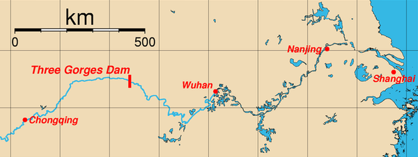
| Locale | Sandouping, Yiling District, Hubei, China |
| Coordinates | |
| Construction began | December 14, 1994 |
| Opening date | 2011 |
| Construction cost | ¥180 billion (US$26 billion) |
| Dam and spillways | |
| Type of dam | Gravity dam |
| Length | 2,335 m (7,661 ft) |
| Height | 185 m (607 ft)[1] |
| Crest width | 40 m (131 ft) |
| Base width | 115 m (377 ft) |
| Impounds | Yangtze River |
| Reservoir | |
| Creates | Three Gorges Reservoir |
| Capacity | 39.3 km3 (31,861,028.5 acre·ft) |
| Catchment area | 1,000,000 km2 (390,000 sq mi) |
| Surface area | 1,045 km2 (403 sq mi) |
| Power station | |
| Turbines | 32 × 750 MW 02 × 50 MW |
| Installed capacity | 22,500 MW |
| Annual generation | 100,000 GWh |
| Bridge | |
| Carries | 177 |
| Toll | ¥10.00 |
| NBI identification | 7649 |
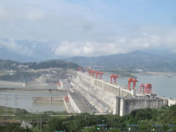
The Three Gorges Dam (simplified Chinese: 长江三峡大坝; traditional Chinese: 長江三峽大壩; pinyin: Chángjiāng Sānxiá Dàbà) is a hydroelectric dam that spans the Yangtze River by the town of Sandouping, located in the Yiling District of Yichang, in Hubei province, China. It is the world's largest electricity-generating plant of any kind.[2]
The dam body was completed in 2006. Except for a ship lift, the originally planned components of the project were completed on October 30, 2008, when the 26th generator in the shore plant began commercial operation. Each generator has a capacity of 700 MW.[3]
Six additional generators in the underground power plant are not expected to become fully operational until 2011. Coupling the dam's 32 main generators with 2 smaller generators (50 MW each) to power the plant itself, the total electric generating capacity of the dam will eventually reach 22.5 GW.[4]
The project produces electricity, increases the river's shipping capacity, and reduces the potential for floods downstream by providing flood storage space. From completion through September 2009 the dam has generated 348.4 TWh of electricity, covering more than one third of its cost.[5]
The Chinese state regards the project as a historic engineering, social and economic success,[6] with the design of state-of-the-art large turbines,[7] and a move toward limiting greenhouse gas emissions.[8] However, the dam flooded archaeological and cultural sites and displaced some 1.3 million people, and is causing significant ecological changes, including an increased risk of landslides.[9] The dam has been a controversial topic both in China and abroad.[10]
Contents |
Project history
The dam was originally envisioned by Sun Yat-sen in The International Development of China, in 1919.[12] He stated that a dam capable of generating 30 million horsepower (22,371 MW) was possible downstream of the Three Gorges.[12] In 1932, the Nationalist government, led by Chiang Kai-shek, began preliminary work on plans in the Three Gorges. In 1939, Japanese military forces occupied Yichang and surveyed the area. A design, the Otani plan, was completed for the dam in anticipation of a Japanese victory over China.[13] In 1944, the United States Bureau of Reclamation chief design engineer, John L. Savage, surveyed the area and drew up a dam proposal for the 'Yangtze River Project'.[14] Some 54 Chinese engineers went to the U.S. for training. Some exploration, survey, economic study, and design work was done, but the government, in the midst of the Chinese Civil War, halted work in 1947.
After the 1949 Communist victory, Mao Zedong supported the project, but began the Gezhouba Dam project first, and economic problems including the Great Leap Forward and the Cultural Revolution slowed progress. In 1958, after the Hundred Flowers Campaign, some engineers who spoke out against the project were imprisoned.[15]
After the 1954 Yangtze River Floods, in 1956, Mao Zedong authored "Swimming", a poem about his fascination with a dam on the Yangtze River. Lines 15-17 read:[16]
| “ | Walls of stone will stand upstream to the west To hold back Wushan's clouds and rain Till a smooth lake rises in the narrow gorges |
” |
During the 1980s, the idea reemerged. The National People's Congress approved the dam in 1992: out of 2,633 delegates, 1,767 voted in favour, 177 voted against, 664 forfeited, and 25 members did not vote.[17] Construction started on December 14, 1994.[1] The dam was expected to be fully operational in 2009, but additional projects such as the underground power plant with six additional generators and the complexity of the ship lift, are expected to delay full operation until about 2011[15] (the ship lift is further out, in 2014.)[18] The dam had raised the water level to 172.5 meters (566 ft) as of the end of 2008.[19]
Layout and scale
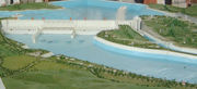
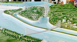
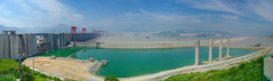
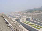
The figure on the right faces upstream. The dam body in the middle left of the figure was divided into the left side (the right one-third of the dam body in this figure), the spillway (the middle of the dam body), and the right side (the left one-third of the dam body in this figure). The underground power plant under construction is to the left of the dam body, hidden in the mountains. The dam wall is made of concrete and is about 29 metres (95 ft) long, and 185 metres (607 ft) high. The wall is 1 metre (3.3 ft) thick on the bottom and 40 metres (131.2 ft) thick on top. The project used 200,000 cubic metres (300,000 cu yd) of concrete, 463,000 tonnes of steel, enough to build 63 Eiffel Towers, and moved about 102,600,000 cubic metres (134,200,000 cu yd) of earth.[20] The ship lift is to the right of the dam body with its own designated waterway. The ship locks, which can be seen in the second figure, are to the right (northeast) of the ship lift.
When the water level is at its maximum of 175 metres (574 ft) over sea level (110 metres or 361 feet above the river level downstream), the dam reservoir is about 660 kilometres (410 mi) in length and 1.12 kilometres (0.70 mi) in width on average, and contains 39.3 km3 (31,900,000 acre·ft) of water. The total surface area of the reservoir is 1,045 km². The reservoir flooded a total area of 632 km² of land, compared to the 1,350 km² of reservoir created by the Itaipu Dam.[21]
Economics
When finished, the project is expected to have cost 180 billion yuan, 12% under budget, approximately 30 billion USD. The lower costs are attributed to a low inflation rate rather than lower spending.[22] By the end of 2008, spending had reached 148.365 billion yuan, among which 64.613 billion yuan was spent on construction, 68.557 billion yuan on relocating affected residents, and 15.195 billion yuan on financing.[23] It is estimated that the construction cost will be recovered when the dam has generated 1,000 TWh of electricity, yielding 250 billion yuan. Full cost recovery is expected to occur ten years after the dam starts full operation.[24]
Funding sources include the Three Gorges Dam Construction Fund, profits from the Gezhouba Dam, loans from the China Development Bank, loans from domestic and foreign commercial banks, corporate bonds, and revenue before and after the dam is fully operational. Additional charges were assessed as follows: Every province receiving power from the Three Gorges Dam has to pay ¥7.00 per MWh extra. Other provinces had to pay an additional charge of ¥4.00 per MWh. Tibet pays no surcharge.[25]
Power generation and distribution
Generating capacity
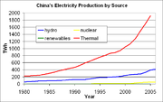
Power generation is managed by China Yangtze Power a listed subsidiary of China Three Gorges Corporation (CTGPC) a Central Enterprise SOE administered by SASAC. The Three Gorges Dam is the world’s largest hydroelectric power station by total capacity, eventually reaching 22,500 MW.[12] It will have 34 generators: 32 main generators, each with a capacity of 700 MW, and two plant power generators, each with capacity of 50 MW. Among those 32 main generators, 14 are installed in the north side of the dam, 12 in the south side, and the remaining six in the underground power plant in the mountain south of the dam. The expected annual electricity generation will be over 100 TWh,[26] 18% more than the originally predicted 84.7 TWh, resulting from the six generators added in 2002.
Generators
The main generators weigh about 6,000 tonnes each and are designed to produce more than 700 MW of power. The designed head of the generator is 80.6 meters (264 ft). The flow rate varies between 600–950 cubic metres (780–1,240 cu yd) depending on the head available. The greater the head, the less water needed to reach full power. Three Gorges uses Francis turbines. Turbine diameter is 9.7/10.4 m (VGS design/Alstom's design) and rotation speed is 75 revolutions per minute. Rated power is 778 MVA, with a maximum of 840 MVA and a power factor of 0.9. The generator produces electrical power at 20 kV. The outer diameter of the generator stator is 21.4/20.9 m. The inner diameter is 18.5/18.8 m. The stator, the biggest of its kind, is 3.1/3 m in height. Bearing load is 5050/5500 tonnes. Average efficiency is over 94%, and reaches 96.5%.[27][28]
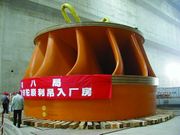
The generators are manufactured by two joint ventures. One of them includes Alstom, ABB Group, Kvaerner, and the Chinese company Haerbin Motor. The other includes Voith, General Electric, Siemens (abbreviated as VGS), and the Chinese company Oriental Motor. The technology transfer agreement was signed together with the contract. Most of the generators are water-cooled. Some newer ones are air-cooled, which are simpler in design and manufacture and are easier to maintain.[29]
Here is a video animation of the Three Gorges Dam generators. [30]
Generator installation progress
The 14 north side generators are in operation. The first (No. 2) started on July 10, 2003 and No. 9 completed things on September 7, 2005. Full power (9,800 MW) was only reached on October 18, 2006 after the water level reached 156 m.[31]
The 12 south side generators are also in operation. No. 22 began operation on June 11, 2007 and No. 15 started up on October 30, 2008.[3] The sixth (No. 17) began operation on December 18, 2007, raising capacity to 14.1 GW, finally surpassing Itaipu (14.0 GW), to become the world's largest hydropower plant.[32][33][34][35]
The underground power plant and its six generators, were still under construction as of December, 2008.[36][37]
Output milestones

By September 16, 2009, the plant had generated 348.4 TWh of electricity,.[38][39] Its 18,300 MW installed capacity is about 4,300 MW more than Itaipu's. In July 2008 it generated 10.3 TWh of electricity, its first month over 10 TWh.[40] On June 30, 2009, after the river flow rate increased to over 24,000 m3, all 28 generators were switched on, producing only 16,100 MW because the head available during flood season is insufficient.[41] During an August 2009 flood, the plant first reached its maximum output for a short period.[42]
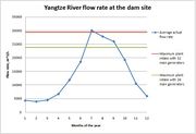
During the November to May dry season, power output is limited by the river's flow rate, as seen in the diagrams on the right. When there is enough flow, power output is limited by plant generating capacity. The maximum power-output curves were calculated based on the average flow rate at the dam site, assuming the water level is 175 m and the plant gross efficiency is 90.15%. The actual power output in 2008 was obtained based on the monthly electricity sent to the grid.)[43][44]
Several factors limited power output in 2008. First, the dam was not operating at 175 m for most of the year, reducing the water flow's potential energy. During the flood season, in order to accommodate water surges, operators lowered the water level to 145 m. Also generators were still being installed—the plant did not reach capacity until the end of the year. Note that the diagrams on the right are based on the power sent to the grid, while the table displays the total generated.
| Year | Number of installed units |
TWh |
|---|---|---|
| 2003 | 6 | 8.607 |
| 2004 | 11 | 39.155 |
| 2005 | 14 | 49.090 |
| 2006 | 14 | 49.250 |
| 2007 | 21 | 61.600 |
| 2008 | 26 | 80.812[45] |
| 2009 | 26 | 79.47[46] |
| Total | 26(32) | 367.984 |
Distribution
The State Grid Corporation and China Southern Power Grid paid a flat rate of ¥250 per MWh ($35.7 US) until July 2, 2008. Since then, the price has varied by province, from ¥230.6-11.1 per MWh. Higher-paying customers receive priority, such as the city of Shanghai.[47] Nine provinces and two cities consume power from the dam.[48]
Power distribution and transmission infrastructure cost about 34.387 billion Yuan. Construction completed in December 2007, one year ahead of schedule.[49]
Power is distributed over multiple 500 kilovolt (kV) transmission lines. Three Direct current (DC) lines to the East China Grid carry 7,200 MW: Three Gorges-Shanghai (3,000 MW), HVDC Three Gorges-Changzhou (3,000 MW), and HVDC Gezhouba - Shanghai (1,200 MW). The alternating current (AC) lines to the Central China Grid have a total capacity of 12,000 MW. The DC transmission line HVDC Three Gorges-Guangdong to the South China Grid has a capacity of 3,000 MW .[50]
The dam was expected to provide 10% China's power. However, demand has increased more quickly than planned. Even fully operational, it would support only about 3% of 2006 requirements.[51]
Environmental effects
Biodiversity
Many of the 3,000 to 4,000 remaining critically endangered Siberian Cranes, wintered in wetlands that the dam destroyed. The dam also contributed to, but was not the major cause of, the functional extinction of the Baiji, the Yangtze river dolphin.
Emissions
Power generation
According to the National Development and Reform Commission of China, 366 grams of coal produces 1 kWh of electricity in China.[52] At full power, Three Gorges reduces coal consumption by 31 million tonnes per year, avoiding 100 million tonnes of greenhouse gas emissions,[53] millions of tonnes of dust, one million tonnes of sulfur dioxide, 370,000 tonnes of nitric oxide, 10,000 tonnes of carbon monoxide, and a significant amount of mercury.[54] Hydropower saves the energy needed to mine, wash, and transport the coal from northern China.
From 2003 to 2007, power production equaled that of 84 million tonnes of standard coal, reducing carbon dioxide by 190 million tons, sulfur dioxide by 2.29 million tonnes, and nitrogen oxides by 980,000 tonnes.[55]
Shipping
The dam increased the Yangtze's barge capacity six-fold, reducing carbon dioxide emission by 630,000 tonnes. From 2004 to 2007 a total of 198 million tonnes of goods passed through the ship locks. Compared to using trucking, barges reduced carbon dioxide emission by ten million tonnes and lowered costs 25%.[55]
Erosion and sedimentation
Two hazards are uniquely identified with the dam.[56] One is that sedimentation projections are not agreed upon, and the other is that the dam sits on a seismic fault.
At current levels, 80% of the land in the area is experiencing erosion, depositing about 40 million tons of sediment into the Yangtze annually.[57] The relocation of people from the reservoir area will cause further deforestation and erosion due to agricultural needs.
Stopping the periodic and uncontrolled flooding of the river will lessen bank erosion. The dam will reduce the amount of silt transported to the Yangtze Delta, eventually reducing the effectiveness of the dam for electricity generation. Perhaps more important, the reduction of downstream silt could result in erosion and sinking of coastal areas.
Excessive sedimentation could block the dam's sluice gates, causing dam failure under some conditions, as occurred with the Banqiao Dam in 1975. Critics claim that the reservoir will average 530 million tons of silt per year. Silt accumulates behind the dam, clogging the turbines' entranceway. However, because China has begun constructing four other megadams upstream since 2006, the sedimentation seems likely to be much less than originally predicted.
The absence of silt downstream has two effects:
- Some hydrologists expect downstream riverbanks to become more vulnerable to flooding.[58]
- The city of Shanghai, more than 1,000 miles (1,609 km) away, rests on a massive sedimentary plain. The "arriving silt—so long as it does arrive—strengthens the bed on which Shanghai is built... the less the tonnage of arriving sediment the more vulnerable is this biggest of Chinese cities to inundation..."[59] Benthic sediment buildup causes biological damage and reduces aquatic biodiversity.[60]
Earthquakes and landslides
Earthquake-induced peak ground acceleration coupled with the immense weight of the reservoir water might be able breach the upstream face of the dam.[61] Erosion in the reservoir, induced by rising water, causes frequent major landslides that have led to noticeable disturbance in the reservoir surface, including two incidents in May 2009 when 50,000 and 20,000 cubic metres (65,000 and 26,000 cu yd) of material plunged into the flooded Wuxia Gorge of the Wu River.[62]
Waste management
The dam catalyzed improved upstream wastewater treatment around the large city of Chongqing and its suburban areas. According to the Ministry of Environmental Protection, as of April 2007 more than 50 new plants could treat 1.84 million tonnes per day, 65% of the total need. About 32 landfills were added, which could handle 7,664.5 tonnes of solid waste every day.[63][64]
Over one billion tons of wastewater are released annually into the river.[57] The dam significantly decreases the river's flushing capacity, and increases pollution load. Cleaning the river of the current pollution load is estimated to cost 2.8 billion Yuan.
Forest cover
The Three Gorges area currently has 10% forestation, down from 20% in the 1950s.[57]
“The FAO’s research suggests that the Asia-Pacific region will, overall, gain about 6,000 square km of forest in 2008. That is quite a turnaround from the 13,000 square km net loss of forest each year in the 1990s. The main reason is China’s huge reforestation effort. This accelerated after terrible floods in 1998 convinced the government that it must restore tree cover, especially in the mighty Yangtze’s basin” upstream of the Three Gorges Dam.[65]
Floods, agriculture, industry
The most significant function of the dam is to control flooding, which is a major problem for the seasonal river of the Yangtze. Millions of people live downstream of the dam, with many large, important cities like Wuhan, Nanjing, and Shanghai situated adjacent to the river. Plenty of farm land and China's most important industrial area are built beside the river.
The reservoir's flood storage capacity is 22 km3 (18 million acre feet. This capacity will reduce the frequency of major downstream flooding from once every ten years to once every 100 years. The dam is expected to minimize the effect of even a "super" flood.[66][67] In 1954 the river flooded 193,000 km2 (74,518 sq mi), killing 33,169 people and forcing 18,884,000 people to move. The flood covered Wuhan, a city of eight million people, for over three months, and the Jingguang Railway was out of service for more than 100 days.[68] The 1954 flood carried 50 billion m3 of water. The dam could only divert the water above Chenglingji, leaving 30 to 40 billion m3 to be diverted.[69] Also the dam could not protect the large tributaries such as the Xiangjiang, Zishui, Yuanshui, Lishui, Hanjiang, and Ganjiang.
In 1998 a flood in the same area caused billions of dollars in damage; 2,039 km2 (787 sq mi) of farm land were flooded. The flood affected more than 2.3 million people, killing 1,526.[70]
In early August 2009, the largest flood in five years passed through the dam site. The dam limited the water flow to less than 40,000 cubic metres (52,000 cu yd) per second, raising the upstream water level from 145.13 metres on August 1, 2009, to 152.88 on August 8, 2009. 4.27 cubic kilometres of flood water were captured and the river flow was cut by as much as 15,000 cubic metres per second.[42]
The dam discharges its reservoir during the dry season between December and March every year.[71] This increases the flow rate of the river downstream, and provides fresh water for agricultural and industrial usage. It also improves shipping conditions. The water level upstream drops from 175 m to 145 m,[72] preparing for the rainy season. The water also powers the Gezhouba Dam downstream.
Since the filling of the reservoir in 2003, the Three Gorges Dam has supplied an extra 11 billion cubic metres of fresh water to downstream cities and farms during the dry season.[73]
In July, 2010, the Three Gorges Dam reached a flood peak of 70,000 cubic meters per second exceeding the peak in 1998 Yangtze River Floods due to the 2010 South China floods, which has caused heavy losses of several cities in Guizhou, Jiangxi, Fujian, Sichuan and Yunnan.[74][75]
Locks
The installation of ship locks is intended to increase river shipping from ten million to 100 million tonnes annually, with transportation costs cut by 30 to 37%. Shipping will become safer, since the gorges are notoriously dangerous to navigate.[55]
Each of the two ship locks is made up of five stages, with transit time at around four hours. Maximum vessel size is 10,000 tons.[76] Critics argue, however, that siltation will clog ports such as Chongqing within a few years based on the evidence from other dam projects.
The locks are 280 m long, 35 m wide, and 5 m deep (918 x 114 x 16.4 ft).[77][78]
That is 30 m longer than those on the St Lawrence Seaway, but half as deep. Before the dam was constructed, the maximum freight capacity at the Three Gorges site was 18.0 million tonnes per year. From 2004 to 2007, a total of 198 million tonnes of freight passed through the locks. The freight capacity of the river increased six times and the cost of shipping was reduced by 25%. The total capacity of the ship locks is expected to reach 100 million tonnes.[55]
Ship lifts
In addition to the canal locks, a ship lift, a kind of elevator for vessels is under construction. The ship lift is designed to be capable of lifting ships of up to 3,000 tons.[79] The original plans specified a lift with the capacity to lift 11,500 ton vessels. The vertical distance traveled will be 113 metres,[80] and the size of the ship lift's basin will be 120x18x3.5 metres. The ship lift, when completed, will take 30 to 40 minutes to transit, as opposed to the three to four hours for stepping through the locks.[81] One complicating factor is that the water level can vary dramatically. The ship lift must work even if water levels vary by 12 meters (39 ft) on the lower side, and 30 metres on the upper side.
The ship lift was not yet complete when the rest of the project was officially opened on May 20, 2006.[82][83] Construction of the ship lift started in October 2007 and is anticipated to be completed in 2014.[18]
Relocation of residents
As of June 2008, China relocated 1.24 million residents, ending with Gaoyang in Hubei Province),[84][85] about 1.5% of the province's 60.3 million and Chongqing City's 31.44 million population.[86] About 140,000 residents were relocated to other provinces.[87]
Relocation was completed on July 22, 2008.[85] Chongqing City will encourage an additional four million people to move away from the dam to the Chongqing metropolitan area by the year 2020.[88][89][90]
Allegedly, funds for relocating 13,000 farmers around Gaoyang disappeared after being sent to the local government, leaving residents without compensation.[91]
Other effects
Culture and aesthetics
The 600 kilometers (373 mi) long reservoir flooded some 1,300 archaeological sites and altered the appearance of the Three Gorges as the water level rose over 600 feet (180 m).[92] Cultural and historical relics are being moved to higher ground as they are discovered, but the flooding inevitably covered undiscovered relics. Some sites could not be moved because of their location, size, or design. For example, the hanging coffins site high in the Shen Nong Gorge is part of the cliffs.[93]
National security
The Department of Defense reported that in Taiwan, “proponents of strikes against the mainland apparently hope that merely presenting credible threats to China’s urban population or high-value targets, such as the Three Gorges Dam, will deter Chinese military coercion.”[94]
The notion that the Taiwanese military would seek to destroy the dam provoked an angry response from the People's Republic of China media. People's Liberation Army General Liu Yuan was quoted in the China Youth Daily saying that the People’s Republic of China would be "seriously on guard against threats from Taiwan independence terrorists."[95]
Structural integrity
Days after the first filling of the reservoir, around 80 hairline cracks were observed in the dam's structure.[96][97][98] The submerged spillway gates of the dam pose a risk of cavitation,[61] of which destroyed the spillways of the Glen Canyon Dam in the floods of 1983.
The project claimed that 163,000 concrete units of the dam all passed quality testing and that deformation was within design limits. An experts group gave the project overall a good quality rating.[99]
Upstream dams
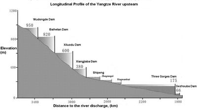
In order to maximize the utility of the Three Gorges Dam and cut down on sedimentation from the Jinsha River, upstream of the Yangtze River before reaching Yibin, China plans to build a series of dams downstream of Jinsha, including Wudongde Dam, Baihetan Dam, Xiluodu Dam, and Xiangjiaba Dam. The total capacity of those four dams is 38,500 MW,[100] almost double the capacity of the Three Gorges.[101] Xiluodu and Xiangjiaba are under construction, while Baihetan is preparing for construction and Wudongde is seeking government approval. Another eight dams are in the midstream of the Jinsha and eight more upstream of it.[102]
In culture
- In Max Brooks’ novel World War Z, the large artificial lake upstream of the dam is the site of the initial zombie outbreak before the war; a superstitious character suggests that the outbreak is retribution for the destruction of ancient holy sites. Later in the novel, the dam is overrun by zombie hordes, which make the emergency pressure release valves impossible to reach. This eventually ruptures the dam, resulting in a massive tsunami which races to the ocean, destroying what remains of Wuhan, Nanjing, and Shanghai, catalyzing the Chinese Civil War.[103]
- In the novel Dragon Bones by Lisa See, a murder investigation takes place at the dam.[104]
- Jia Zhangke's film Still Life describes the destiny of two couples with dam connections.
- Yung Chang's 2007 award-winning documentary film, Up the Yangtze, features the effects of the dam on various people along the Yangtze River.
- Jennifer Baichwal's 2006 award-winning documentary film, Manufactured Landscapes about the work of photographer Edward Burtynsky. The film follows Burtynsky on a tour of China as he takes large-scale photographs of industrial subjects.
- Robert Ferrigno's 2006 novel Prayers for the Assassin involves a massive nuclear bomb found at the base of the dam.[105]
- Nevermore's song "The River Dragon Has Come," from the album Dead Heart In a Dead World, describes the breaking of the Three Gorges Dam.
- The dam is featured as a world wonder in Sid Meier's Civilization IV.
See also
- Energy policy of China
- Hydroelectricity
- List of largest hydroelectric power stations
- List of largest power stations in the world
- List of conventional hydroelectric power stations
- List of dam megaprojects
- List of power stations in China
- Megaproject
- Megaprojects and risk
References
- ↑ 1.0 1.1 Allin, Samuel Robert Fishleigh (2004-11-30) (PDF). An Examination of China’s Three Gorges Dam Project Based on the Framework Presented in the Report of The World Commission on Dams. Virginia Polytechnic Institute and State University. http://scholar.lib.vt.edu/theses/available/etd-12142004-125131/unrestricted/SAllin_010304.pdf. Retrieved 2008-01-13.
- ↑ "top-100-pt-4". Industcards.com. http://www.industcards.com/top-100-pt-4.htm. Retrieved 2009-08-01.
- ↑ 3.0 3.1 "三峡工程左右岸电站26台机组全部投入商业运行" (in Chinese). China Three Gorges Project Corporation. 2008-10-30. http://www.ctgpc.com.cn/sx/news.php?mNewsId=30559. Retrieved 2008-12-06.
- ↑ ":: Three Gorges reservoir raises water to target level". Xinhua. 2008-10-07. http://news.xinhuanet.com/english/2008-10/07/content_10162045.htm. Retrieved 2008-10-14.
- ↑ "峡工程09年发电可望再创历史新高". 世华财讯. http://content.caixun.com/NE/01/j1/NE01j1lg.shtm. Retrieved 2009-09-17.
- ↑ "中国长江三峡工程开发总公司". Ctgpc.com.cn. 2009-04-08. http://www.ctgpc.com.cn/sx/news.php?mNewsId=32819. Retrieved 2009-08-01.
- ↑ "中国长江三峡工程开发总公司". Ctgpc.com.cn. 2009-03-10. http://www.ctgpc.com.cn/sx/news.php?mNewsId=32325. Retrieved 2009-08-01.
- ↑ "一座自主创新历史丰碑 三峡工程的改革开放之路". Hb.xinhuanet.com. http://www.hb.xinhuanet.com/zhibo/2009-02/03/content_15593414.htm. Retrieved 2009-08-01.
- ↑ "重庆云阳长江右岸现360万方滑坡险情-地方-人民网". Unn.people.com.cn. http://unn.people.com.cn/GB/9105724.html. Retrieved 2009-08-01. See also: "探访三峡库区云阳故陵滑坡险情". News.xinhuanet.com. http://news.xinhuanet.com/newscenter/2009-04/09/content_11157017.htm. Retrieved 2009-08-01.
- ↑ Lin Yang (12 October 2007). "China's Three Gorges Dam Under Fire". Time. http://www.time.com/time/world/article/0,8599,1671000,00.html. Retrieved 28 March 2009. "The giant Three Gorges Dam across China's Yangtze River has been mired in controversy ever since it was first proposed" See also: Laris, Michael (17 August 1998). "Untamed Waterways Kill Thousands Yearly". Washington Post. http://www.washingtonpost.com/wp-srv/inatl/longterm/china/stories/death081798.htm. Retrieved 28 March 2009. "Officials now use the deadly history of the Yangtze, China's longest river, to justify the country's riskiest and most controversial infrastructure project – the enormous Three Gorges Dam." and Grant, Stan (18 June 2005). "Global Challenges: Ecological and Technological Advances Around the World". CNN. http://edition.cnn.com/TRANSCRIPTS/0506/18/gc.01.html. Retrieved 28 March 2009. "China's engineering marvel is unleashing a torrent of criticism. [...] When it comes to global challenges, few are greater or more controversial than the construction of the massive Three Gorges Dam in Central China." and Gerin, Roseanne (11 December 2008). "Rolling on a River". Beijing Review. http://www.bjreview.com.cn/eye/txt/2008-12/06/content_168792.htm. Retrieved 28 March 2009. "..the 180-billion yuan ($26.3 billion) Three Gorges Dam project has been highly contentious."
- ↑ ""Swimming" by Mao Zedong". Marxists.org. http://www.marxists.org/reference/archive/mao/selected-works/poems/poems23.htm. Retrieved 2009-08-01.
- ↑ 12.0 12.1 12.2 "中国国民党、亲民党、111新党访问团相继参观三峡工程_新闻中心_新浪网". News.sina.com.cn. http://news.sina.com.cn/c/2006-10-23/113410303856s.shtml. Retrieved 2009-08-01.
- ↑ [1]
- ↑ http://books.nap.edu/html/biomems/jsavage.pdf John Lucian Savage Biography by Abel Wolman & W. H. Lyles, National Academy of Science, 1978.
- ↑ 15.0 15.1 Steven Mufson (1997-11-09). "The Yangtze Dam: Feat or Folly?". Washington Post. http://www.washingtonpost.com/wp-srv/inatl/longterm/yangtze/yangtze.htm. Retrieved 2008-01-20.
- ↑ Imperial Tours - Three Gorges Dam
- ↑ "1992年4月3日全国人大批准兴建三峡工程". News.rednet.cn. http://news.rednet.cn/c/2008/05/19/1510741.htm. Retrieved 2009-08-16.
- ↑ 18.0 18.1 "三峡升船机开工建设_荆楚网 (Three Gorges ship lift operation construction)". CnHubei. 2007-11-10. http://news.cnhubei.com/hbrb/hbrbsglk/hbrb01/200711/t136849.shtml. Retrieved 2008-08-09. translation
- ↑ "三峡完成172.5米蓄水 中游航道正常维护(图)-搜狐新闻". News.sohu.com. http://news.sohu.com/20081106/n260480174.shtml. Retrieved 2009-08-16.
- ↑ "Three Gorges Dam Project — Quick Facts". ibiblio.org. http://www.ibiblio.org/chinesehistory/contents/07spe/specrep01.html#Quick%20Facts. Retrieved 2008-01-20.
- ↑ "三峡水库:世界淹没面积最大的水库 (Three Gorges reservoir: World submergence area biggest reservoir)". Xinhua Net. 2003-11-21. http://news.xinhuanet.com/ziliao/2003-05/30/content_896773.htm. Retrieved 2008-04-10.
- ↑ "Brief explanation of TGP" (in Chinese). China Three Gorges Project Corporation. 2006-05-20. http://www.ctgpc.com.cn/sxslsn/index.php. Retrieved 2007-05-27.
- ↑ "国家重大技术装备". Chinaneast.xinhuanet.com. 2009-01-11. http://chinaneast.xinhuanet.com/jszb/2009-01/11/content_15419027.htm. Retrieved 2009-08-01.
- ↑ "International Water Power and Dam Construction". Waterpowermagazine.com. 2007-01-10. http://www.waterpowermagazine.com/story.asp?storyCode=2041318. Retrieved 2009-08-01.
- ↑ "Three Gorges Dam" (in Chinese). China Three Gorges Project Corporation. 2003-04-20. http://www.ctgpc.com.cn/sx/sxgczds.php?mClassId=015004. Retrieved 2007-04-29.
- ↑ "三峡机组国产化已取得成功" (in Chinese). hb.xinhuanet.com. 2008-12-04. http://www.hb.xinhuanet.com/zhibo/2008-12/04/content_15097047.htm. Retrieved 2008-12-06.
- ↑ "李永安:我水轮发电机组已具完全自主设计制造能力_财经频道_新华网" (in Chinese). xinhuanet.com. 2008-08-28. http://news.xinhuanet.com/fortune/2008-08/28/content_9723523_2.htm. Retrieved 2008-12-06.
- ↑ THREE GORGES DAM by Matthew Morioka, Alireza Abrishamkar, Yve Kay CEE 491
- ↑ "三峡工程及其水电机组概况 (Three Gorges Project and water and electricity unit survey)" (in Chinese). 中华商务网讯. 2002-07-26. http://www.chinaccm.com/23/2307/230701/news/20020726/105549.asp. Retrieved 2008-04-11. translation
- ↑ “”. "Three Gorges Power Plant Animation". YouTube. http://www.youtube.com/watch?v=tjTh7A4jnbc. Retrieved 2010-08-20.
- ↑ "Three Gorges Dam" (in Chinese). Government of China. 2006-10-18. http://www.gov.cn/jrzg/2006-10/18/content_416256.htm. Retrieved 2007-05-15.
- ↑ "中国长江三峡工程开发总公司 (The manufacture domestically large-scale power set stability enhances unceasingly)". ctgpc. 2008-05-05. http://www.ctgpc.com.cn/sx/news.php?mNewsId=28253. Retrieved 2008-08-09. translation
- ↑ "三峡右岸电站19号机组完成72小时试运行" (in Chinese). China Three Gorges Project Corporation. 2008-06-20. http://www.ctgpc.com.cn/sx/news.php?mNewsId=28982. Retrieved 2008-12-06.
- ↑ "中国长江三峡工程开发总公司". Ctgpc.com.cn. 2008-07-04. http://www.ctgpc.com.cn/sx/news.php?mNewsId=29089. Retrieved 2009-08-01.
- ↑ "三峡23号机组进入72小时试运行" (in Chinese). China Three Gorges Project Corporation. 2008-08-22. http://www.ctgpc.com.cn/sx/news.php?mNewsId=29622. Retrieved 2008-12-06.
- ↑ "Three Gorges Dam" (in Chinese). Xinhua. 2007-10-22. http://www.hb.xinhuanet.com/newscenter/2007-10/23/content_11470543.htm. Retrieved 2007-10-22.
- ↑ "Three Gorges Dam (三峡电站累计发电2050亿千瓦时 装机容量居世界首位)" (in Chinese). Xinhua. 2007-12-08. http://chinaneast.xinhuanet.com/jszb/2007-12/08/content_11882715.htm. Retrieved 2007-12-08.
- ↑ "三峡电站首次实现26台机组全部同时并网发电". Sasac.gov.cn. http://www.sasac.gov.cn/n1180/n1226/n2410/n314274/6500480.html. Retrieved 2009-08-16.
- ↑ "三峡工程左右岸电站26台机组全部投入商业运行 - 中国报道 - 国际在线" (in Chinese). CRI online. 2008-10-30. http://gb.cri.cn/18824/2008/10/30/2945s2302630.htm. Retrieved 2008-12-06.
- ↑ "三峡电站月发电量首过百亿千瓦时" (in Chinese). China Three Gorges Project Corporation. 2008-08-15. http://www.ctgpc.com.cn/sx/news.php?mNewsId=29583. Retrieved 2008-12-06.
- ↑ "三峡电站26台发电机组投产后首次满负荷发电". Hb.xinhuanet.com. http://www.hb.xinhuanet.com/zhibo/2009-06/30/content_16958373.htm. Retrieved 2009-08-01.
- ↑ 42.0 42.1 "中国长江三峡工程开发总公司". Ctgpc.com.cn. http://www.ctgpc.com.cn/sx/news.php?mNewsId=35674. Retrieved 2009-08-16.
- ↑ "国家电网公司-主要水电厂来水和运行情况". Sgcc.com.cn. http://www.sgcc.com.cn/dwxx/qydwyxqk/lsyxqk/default.shtml. Retrieved 2009-08-01.
- ↑ "国家电网公司-国调直调信息系统". Sgcc.com.cn. http://www.sgcc.com.cn/dwxx/sgddxx/gdzdxxxt/default.shtml. Retrieved 2009-08-01. State Grid Corporation
- ↑ "中国电力新闻网――电力行业的门户网站". Cepn.sp.com.cn. http://www.cepn.sp.com.cn/bwtj/200901/t20090109_268374.htm. Retrieved 2009-08-01.
- ↑ "国家重大技术装备". Chinaequip.gov.cn. 2010-01-08. http://www.chinaequip.gov.cn/2010-01/08/c_13130850.htm. Retrieved 2010-08-20.
- ↑ "中国长江三峡工程开发总公司". Ctgpc.com.cn. 2008-07-04. http://www.ctgpc.com.cn/sx/news.php?mNewsId=29096. Retrieved 2009-08-01.
- ↑ "Construction of the Three Gorges Project and Ecological Protection". Chinagate.com.cn. 2007-11-27. http://en.chinagate.com.cn/reports/2007-12/05/content_9348644.htm. Retrieved 2008-01-20.
- ↑ "Three Gorges Dam" (in Chinese). National Development and Reform Commission. 2007-12-20. http://www.sdpc.gov.cn/xwfb/t20071220_180047.htm. Retrieved 2007-12-20.
- ↑ "Three Gorges, China". ABB Group. http://www.abb.com/cawp/gad02181/f5933693d1a92404c1256d8800401782.aspx. Retrieved 2007-12-20.
- ↑ "Three Gorges Dam" (in Chinese). Chinese Society for electrical engineering. 2006-05-25. http://www.csee.net.cn/data/2006/0525/article_864.htm. Retrieved 2007-05-16.
- ↑ "Three Gorges Dam" (in Chinese). NDRC. 2007-03-07. http://www.ndrc.gov.cn/zjgx/t20070307_120213.htm. Retrieved 2007-05-15.
- ↑ "Greenhouse Gas Emissions By Country". Carbonplanet. 2006. http://www.carbonplanet.com/home/country_emissions.php. Retrieved 2007-05-16.
- ↑ "Three Gorges Dam" (in Chinese). TGP. 2006-06-12. http://www.ctgpc.com.cn/sxslsn/index.php. Retrieved 2007-05-15.
- ↑ 55.0 55.1 55.2 55.3 "长江电力(600900)2008年上半年发电量完成情况公告 - 证券之星 (The Three Gorges sluice year transported goods volume may amount to 100,000,000 tons)". Xinhua. 2007-01-23. http://news.stockstar.com/info/darticle.aspx?id=GA,20080708,00069957&columnid=76. Retrieved 2008-08-09. translation
- ↑ Topping, Audrey Ronning. Environmental controversy over the Three Gorges Dam. Earth Times News Service.
- ↑ 57.0 57.1 57.2 Qing, Dai, 9. The River Dragon Has Come!: The Three Gorges Dam and the Fate of China's Yangtze River and Its People (East Gate Book). Armonk, New York: M.E. Sharpe, 1997.
- ↑ "三峡大坝之忧". Chinese.wsj.com. 2007-08-28. http://chinese.wsj.com/gb/20070829/chw110745.asp?source=baidu. Retrieved 2009-08-16.
- ↑ Winchester, Simon (1998). The River at the Center of the World. New York: Henry Holt & Co. p. 228. ISBN 9780805055085.
- ↑ Segers, Henrik; Martens, Koen (2005). The River at the Center of the World. Springer. p. 73. ISBN 9781402037450.
- ↑ 61.0 61.1 "Chapter 10: Dam Safety Analysis". Damming the Three Gorges. http://www.threegorgesprobe.org/pi/documents/three_gorges/Damming3G/ch10.html. Retrieved 2009-06-03.
- ↑ Yang, Sung. "No Casualties in Three Gorges Dam Landslide". Xinhua News Network. CRIEnglish.com. http://english.cri.cn/6909/2009/05/19/45s485830.htm. Retrieved 2009-06-03.
- ↑ "重庆三峡库区污水和垃圾处理项目建设成效明显 (Chongqing Three Gorges Reservoir Region sewage and the garbage disposal project construction result is obvious)". 2007-04-19. http://www.zhb.gov.cn/info/gxdt/200704/t20070419_102933.htm. Retrieved 2008-08-09. translation
- ↑ "湖北省三峡治污项目三年内投入约23.5亿元 (In the Hubei Province Three Gorges anti-pollution project three years invest the approximately 2,350,000,000 Yuan)". Xinhua. 2007-04-19. http://www.hb.xinhuanet.com/zhibo/2008-05/03/content_13148105.htm. Retrieved 2008-08-09. translation
- ↑ Peter Collins, "Falling here, rising there" Page 63, The World in 2008, The Economist
- ↑ "三峡工程的防洪作用将提前两年实现-经济-人民网". Finance.people.com.cn. http://finance.people.com.cn/GB/1039/60370/62598/63180/4385148.html. Retrieved 2009-08-01.
- ↑ "三峡工程防洪、通航、发电三大效益提前全面发挥". Chn-consulate-sapporo.or.jp. 2006-05-16. http://www.chn-consulate-sapporo.or.jp/chn/ztxw/t252626.htm. Retrieved 2009-08-01.
- ↑ "39.1931、1935、1954、1998年长江流域发生的4次大洪水造成了怎样的洪水灾害??". People.com.cn. http://www.people.com.cn/GB/jinji/222/10814/10824/10831/20030529/1003614.html. Retrieved 2009-08-01.
- ↑ Dai, Qing. Yangtze! Yangtze!. UK: Earthscan Ltd, 1994., 184
- ↑ "Three Gorges Dam" (in Chinese). CTGPC. 2002-04-20. http://www.ctgpc.com.cn/sxslsn/index.php?mClassId=003000. Retrieved 2007-06-03.
- ↑ "经过不懈努力三峡枢纽主体工程建设任务提前完成". Gov.cn. http://www.gov.cn/jrzg/2009-02/18/content_1235518.htm. Retrieved 2009-08-01.
- ↑ "三峡水库可如期消落至145米汛限水位". Hb.xinhuanet.com. http://www.hb.xinhuanet.com/zhibo/2009-02/19/content_15732434.htm. Retrieved 2009-08-01.
- ↑ "中国长江三峡工程开发总公司". Ctgpc.com.cn. 2009-08-07. http://www.ctgpc.com.cn/sx/news.php?mNewsId=35412. Retrieved 2009-08-16.
- ↑ Three Gorges Dam will meet the first large-scale flood since being completed July 20, 2010. Retrieved July 20, 2010.
- ↑ (Chinese)"三峡迎来7万立方米/秒特大洪峰 规模超1998年". SINA Corporation. http://news.sina.com.cn/c/2010-07-20/090920716433.shtml.
- ↑ "Yangtze as a vital logistics aid" (in Chinese). China Economic Review. 2007-05-30. http://www.chinaeconomicreview.com/logistics/?cat=88. Retrieved 2007-06-03.
- ↑ "Three Gorges Dam". Missouri Chapter American Fisheries Society. 2002-04-20. http://www.moafs.org/newsletter/April%202002/3gorgestats.htm. Retrieved 2007-01-28. mirror
- ↑ "Its Buildings with Biggest Indices". China Three Gorges Project. 2002. http://www.ctgpc.com/benefifs/benefifs_a_5.htm. Retrieved 2007-01-28.mirror
- ↑ "China's west seeks to impress investors". BBC. 2005-05-04. http://news.bbc.co.uk/2/hi/business/4512015.stm. Retrieved 2007-01-28. mirror
- ↑ "Its Buildings with Biggest Indices". China Three Gorges Project. 2002. http://www.ctgpc.com/benefifs/benefifs_a_5.htm. Retrieved 2007-01-28.
- ↑ "China's west seeks to impress investors". BBC. May 4, 2005. http://news.bbc.co.uk/2/hi/business/4512015.stm. Retrieved 2007-01-28.
- ↑ "Three Gorges dam ready to go". Taipei Times. 2006-05-21. http://www.taipeitimes.com/News/world/archives/2006/05/21/2003309291. Retrieved 2007-01-28. mirror
- ↑ "China Completes Three Gorges Dam". CBS News. 2006-05-20. http://www.cbsnews.com/stories/2006/05/20/world/main1638180.shtml. Retrieved 2007-01-28. mirror
- ↑ "三峡四期移民工程通过阶段性验收" (in Chinese). China Three Gorges Project Corporation. 2008-08-22. http://www.ctgpc.com.cn/sx/news.php?mNewsId=29626. Retrieved 2008-12-06.
- ↑ 85.0 85.1 "中港台] 三峡库区城镇完成拆迁-华尔街日报". Chinese.wsj.com. http://chinese.wsj.com/gb/20080724/bch094619.asp?source=whatnews3. Retrieved 2009-08-01.
- ↑ "China dam to displace millions more". MWC News. 2007-10-13. http://mwcnews.net/content/view/17341&Itemid=1. Retrieved 2007-10-13.
- ↑ Liang Chao (2004-07-15). "More bid farewell to Three Gorges". China Daily. http://www.chinadaily.com.cn/english/doc/2004-07/15/content_348413.htm. Retrieved 2008-01-20.
- ↑ "Millions forced out by China dam". BBC News. 2007-10-12. http://news.bbc.co.uk/2/hi/asia-pacific/7042660.stm. Retrieved 2008-01-20.
- ↑ Wang Hongjiang (2007-10-11). "Millions more face relocation from Three Gorges Reservoir Area". Xinhua. http://news.xinhuanet.com/english/2007-10/11/content_6864252.htm. Retrieved 2008-01-20.
- ↑ Jiang Yuxia (2007-09-26). "China warns of environmental "catastrophe" from Three Gorges Dam". Xinhua. http://news.xinhuanet.com/english/2007-09/26/content_6796234.htm. Retrieved 2007-10-14.
- ↑ Julie Chao (2001-05-15). "Relocation for Giant Dam Inflames Chinese Peasants". National Geographic. http://news.bbc.co.uk/2/hi/asia-pacific/1925172.stm. Retrieved 2008-01-20.
- ↑ Regine Debatty (2007-12-09). "Flotsam, Jetsam and the Three Gorges Dam". World Changing. http://www.worldchanging.com/archives/007682.html. Retrieved 2008-01-20.
- ↑ C.Michael Hogan. "Shen Nong Gorge Hanging Coffins". The Megalithic Portal. http://www.megalithic.co.uk/article.php?sid=17946. Retrieved 2008-01-20.
- ↑ "Annual report on the military power of the People's Republic of China (.pdf)". US Department of Defense. http://www.defenselink.mil/pubs/d20040528PRC.pdf. Retrieved 2007-01-28.
- ↑ "Troops sent to protect China dam". BBC. 2004-09-14. http://news.bbc.co.uk/1/hi/world/asia-pacific/3654772.stm. Retrieved 2007-01-28.
- ↑ "Three Gorges Dam". International Rivers. http://internationalrivers.org/en/china/three-gorges-dam. Retrieved 2009-06-03.
- ↑ Adams, Jerry. "Three Gorges Dam". Electronic Data Interchange. Awesome Library. http://www.awesomelibrary.org/Library/Local_Information/Asia/China/Three_Gorges_Dam.html. Retrieved 2009-06-03.
- ↑ "Three Gorges Dam". Living On Earth. http://www.loe.org/series/3gorges/. Retrieved 2009-06-03.
- ↑ "三峡工程质量处于良好受控状态". Aqsiq.gov.cn. http://www.aqsiq.gov.cn/zjxw/zjxw/zjftpxw/200907/t20090721_122359.htm. Retrieved 2009-08-16.
- ↑ "中国三峡总公司拟在金沙江上建4座梯级水电站 总装机容量为3850万千瓦_中国电力网(www.chinapower.com.cn)新闻中心". www.chinapower.com.cn. http://www.chinapower.com.cn/newsarticle/1008/new1008554.asp. Retrieved 2009-08-01.
- ↑ "Beijing Environment, Science and Technology Update". U.S. Embassy in China. 2003-03-07. http://www.usembassy-china.org.cn/sandt/estnews030703.htm. Retrieved 2008-01-20.
- ↑ "Beyond Three Gorges in China". Water Power Magazine. 2007-01-10. http://www.waterpowermagazine.com/story.asp?storyCode=2041318. Retrieved 2007-10-13.
- ↑ Matthew S. Muller. Amazon.com review of World War Z: An Oral History of the Zombie War.
- ↑ "Lisa See — Dragon Bones". http://www.lisasee.com/dragonbones.htm. Retrieved 2008-01-19.
- ↑ Ferrigno, Robert (2006). Prayers for the Assassin. Charles Scribner's Sons. p. 211. ISBN 0-743-27289-7.
External links
- Digital Times' coverage
- International Rivers - information page on the project
- BBC News Online - Troops to protect dam against terrorists - September 14, 2004.
- BBC News Dam wall completed - May 2006
- BBC News In pictures: Three Gorges Dam - May 20, 2006.
- chinadialogue 中国与世界,环境危机大家谈 - article about the politics of water in China
- Up the Yangtze - a documentary film about the impact of the project
- Three Gorges Dam Tourism - a tourist's view of the Three Gorges Dam
- "Three Gorges dam's social impact" by Jill McGivering, BBC News, May 20, 2006, retrieved May 20, 2006
- "As China's mega dam rises, so do strains and fear" Reuters November 14, 2007
- Jim Yardley (2007-11-21). "Chinese Dam Projects Criticized for Their Human Costs". New York Times. http://www.nytimes.com/2007/11/19/world/asia/19dam.html?fta=y&pagewanted=all. Retrieved 2007-12-09.
- Jim Yardley (2007-11-22). "China to Address Issues Around Dam". New York Times. http://www.nytimes.com/2007/11/22/world/asia/22gorges.html?fta=y. Retrieved 2007-12-09.
- Anderlini, Jamil (2007-10-31). "Sold down the river". Financial Times. http://www.ft.com/cms/s/0/20d888b0-87d1-11dc-9464-0000779fd2ac.html?nclick_check=1. Retrieved 2008-01-20.
- Three Gorges Probe (2008-03-18). "Three Gorges Oral History Series: Absence of Justice: Lu Chengming's Struggle for Compensation". http://www.probeinternational.org/catalog/content_fullstory.php?contentId=6790&cat_id=7.
- Yang Lei (20 May 2006). "Three Gorges dam to facilitate flood control ahead of time". Chinese Government. http://english.gov.cn/2006-05/20/content_286525.htm.
|
|||||||||||||||||